We recently completed our study of Native American groups that lived in Texas prior to European contact. The class was divided into four groups, each of which studied a different tribe. Groups had to use the textbook and information from the internet to research what daily life was like for their tribes. They were responsible for obtaining information about the following topics: the region in which the tribe lived, shelter, clothing, food, dealings with other tribes, and any other information they thought might be of interest. The groups then used their research to create murals representing typical daily life for their tribe. Once the murals were finished, each group presented its work to the class, explaining the details in its mural while classmates took notes on each presentation. Click on any of the pictures below to view an interactive version of that mural. Move the mouse over different areas of the mural to learn more about each tribe.
Recientemente terminamos nuestros estudios sobre los indígenas que vivían en Texas antes de la llegada de los europeos. La clase se dividió en cuatro grupos, y cada uno estudió una tribu diferente. Los grupos utilizaron sus libros e información del internet para investigar la vida diaria de su tribu. Fueron responsables de encontrar información sobre los siguientes temas: la región en la que vivían, sus viviendas, su alimentación, sus relaciones con otros grupos indígenas y cualquier otro dato de interés. Después de completar sus investigaciones, los alumnos usaron la información que encontraron para crear murales representativos de la vida típica de su tribu. Luego, cada grupo presentó su mural a la clase, explicando los detalles mientras los compañeros de clase tomaban apuntes sobre cada presentación. Haz clic en cualquiera de las imágenes de abajo para ver una versión interactiva de ese mural. Mueve el mouse sobre diferentes áreas del mural para descubrir más sobre cada tribu.
Tuesday, October 27, 2009
Monday, October 5, 2009
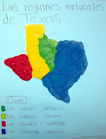
Natural Regions of Texas/Las regiones naturales de Texas
Last Friday we made salt maps showing the natural regions of Texas. It took about an hour to finish, and we all had a lot of fun. First, students drew the natural regions on a map of Texas. Next, they filled in the regions with different colored salt mixtures. Once the maps were complete, they cut the wet maps out and glued them to a piece of sturdy card stock. The final step was to create a map key and give the map a title. If you would like to try this at home, we used the recipe below for each color of the salt mixture. The measures given make enough salt mixture for two full classes, so you will probably want to cut the recipe in half.
1 cup salt
2 cups flour
3/4 cup water
1 small tube or bottle of food coloring
Make sure you get help from an adult if you decide to try this. I hope you have as much fun as we did!
El viernes pasado hicimos mapas de "mazapán" de las regiones naturales de Texas. Nos demoramos una hora para terminarlos, y nos divertimos mucho. Para empezar, los alumnos dibujaron los límites de las regiones en un mapa en blanco de Texas. Después, llenaron cada región con un color diferente de "mazapán," una mezcla de sal, harina y agua. Una vez que terminaron los mapas, los recortaron y los pegaron a una hoja de cartulina. El paso final fue crear una clave para explicar el significado de cada color y ponerle título a los mapas. Usamos la receta abajo por si acaso te gustaría hacerlo en casa. Las medidas hacen suficiente "mazapán" de cada color para dos clases, así que a lo mejor querrás usar la mitad de las medidas dadas.
1 taza de sal
2 tazas de harina
3/4 taza de agua
1 tubo o frasco pequeño de colorante
Asegúrate de conseguir la ayuda de un adulto si decides intentar esto. ¡Espero que lo disfrutes tanto como nosotros lo hicimos!
Subscribe to:
Posts (Atom)


